

Benthic Towed Camera Survey
In September 2010 RET undertook a video survey of the seabed in the Big Russel and south of St Martins Point. The survey aims to improve our knowledge of the benthic marine environment in the rocky seabed in the Bailiwick and start to fill in some of the knowledge gaps identified by the Regional Environmental Assessment (REA).
The project was undertaken RET working with members of the tidal energy research team at PRIMaRE (Peninsular Research Institute for Marine Renewable Energy), Universities of Plymouth and Exeter. Dr. Emma Sheehan led the survey having previously completed similar surveys at the Wave Hub site in Cornwall and in Lyme Bay. The survey was for 10 days and was completed in 10 consecutive days from Monday 13th September to Wednesday 22nd September 2010.
The survey focussed primarily on the Big Russel as this area has been identified as possibly having the best tidal resource locally, as outlined in Appendix C of the REA (3.6mb), and also sufficient depth of water and space to accommodate tidal energy devices. In cases like this where development is possible, a “control” site must be identified and surveyed as well. An area south of St Martins Point was identified as being of similar substrate and tidal conditions to the Big Russel, and so a number of tows were performed there as well. This allows comparisons to be made between a developed site and the control site in the future. A local fishing trawler, the “Nicola May”, operated by Mr Shane Petit, was used to conduct the survey.
The survey used a specially designed metal framed sledge that was towed over the seabed beneath the fishing vessel. The sledge was mounted with lights and a high definition video camera that took video footage of the seabed. This information was recorded onto a computer on board the vessel via a glass fibre optic cable connected to the sledge, and could be played back to analyse the different types and density of life on the sea bed.
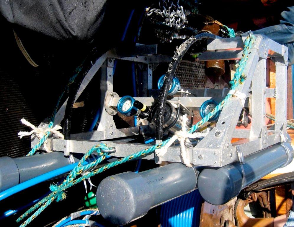
Photograph of the towed sled and camera taken on board the Nicola May.
The information gathered will be stored and used as a baseline to see how sea life is affected by any future tidal energy development. The exact position of the sledge was recorded by global positioning system (GPS), as well as written positions taken every five minutes of the tow. The water temperature, depth and salinity were all also recorded by the device.
In total, 90 tows were conducted over the 10 day period, with 82 of these being useful for analysis of the seabed. The main reason for the other tows not being used is that the tide was moving too fast, meaning that the definition of the video image would not be suitable to work from. Each tow lasted for 20 minutes, covering approximately 200 metres in that time, depending on the state of the tide. The visibility in the Big Russel was hampered by “snow” which is comprised of suspended sediment and organic matter being swept along by the tidal currents. This meant that the camera had to “fly” fairly close to the seabed, giving each tow a view of about a 35-45cm strip of the seabed.
The camera information was then analysed at the University of Plymouth and the report is available to view here.
Latest News
- 04/08/2017 - LiDAR and power unit to be deployed at Chouet
- 18/05/2017 - RET Publish Offshore Wind Feasibility Report
- 01/04/17 - RET releases 2017 strategy and review of 2016
- 01/08/2016 - Congratulations to Bouke Wiersma on completion of his Public Engagement PhD in Guernsey
- 21/07/2016 - Working with Universities – Update
- 01/05/2016 - Renewable energy work under new Committee
- 19/04/2016 - RET open Day at Beau Sejour
- Commerce and Employment Renewable Energy Team to undertake Open Day and associated Poster Display
- 01/01/16 - RET releases 2016 strategy and review of 2015
- 23/11/15 - Consultants Appointed for Offshore Wind Work
- November 12th & 13th - University of Exeter Festival of Social Science: Visualising public engagement with marine renewable energies
- 30/10/15 - Renewable Energy Legislation Passed
- 14/10/15 CIMREG Officers Meeting Held in Guernsey
- 08/09/2015 - Commerce and Employment and Guernsey Electricity Limited continue feasibility work into local offshore wind energy project
- 01/08/2015 - RET Continue to Work with Universities
- 30/06/2015 - Results from Island Wide Survey on Offshore Renewable Energy Shows Strong Support for Renewables
- 18/06/2015 - RET release renewable energy ordinance response document
- 20/05/2015 - Thetis EMR conference
- 21/04/2015 - Channel Islands Marine Renewable Energy Group Political Summit
- 28/01/2015 - Public Engagement PhD - Guernsey Opinion Survey: Renewable Energy